
Introduction

Art-Deco Lincoln Bank Tower
|
Population and Size
Fort Wayne, located in northeastern Indiana, is the county seat of Allen County and the second largest city in the state behind the capital city of Indianapolis. According to the U.S. Census Bureau, the city had a total population of 253,691 at the 2010 Census, and it has been estimated that the population has grown to 254,555 for the year 2012. In 2010 the City of Fort Wayne encompassed an area of 110.62 square miles, which is roughly equivalent to 70,797 acres. Taking into account both population and land area, the overall population density for the city in 2010 was roughly 2,293 persons per square mile [15]. For historic Census population records, click here.
The total Census population in 2010 for Allen County was 355,329, resulting in a population density of 541 people per square mile. By difference, only 101,638 people who lived in Allen County in 2010 did not also live in the City of Fort Wayne, meaning that Fort Wayne accounts for a large majority of the entire County’s population (71.4%). The city on its own also accounts for a majority of the population (60.9%) in the Fort Wayne Metropolitan Statistical Area (MSA), comprising Allen, Wells and Whitley Counties [1]. Economy
According to estimates released by U.S. Bureau of Labor Statistics (BLS) for 2012, the three largest employment sectors in the Fort Wayne MSA were Office and Administrative Support (29,270 employees), Production Occupations (25,390 employees), and Sales & Related Occupations (21,600 employees). Though these are the largest sectors by employment, the Location Quotient (LQ) estimates released by the BLS are better indicators of the most well-developed sectors based on U.S. sector employment as a benchmark, where a value above 1 indicates above-average specialization. The three sectors with the highest LQs in 2012 were Production Occupations (1.93), Healthcare Practitioners and Technical Occupations (1.17), and Transportation & Material Moving Occupations (1.14) [19]. These numbers suggest that the Fort Wayne economy has a strong base in manufacturing and logistics operations as well as health care services.
|
|
Spatial Structure
As shown by the regional map to the right, the physical structure of Fort Wayne is unique in many ways – beginning with the fact that the two Interstate highways traversing the region (I-69 and the I-469 bypass) had historically been routed away from the downtown and other neighborhoods in the historic central core.
I-69 skirts the peripheral boundaries of the city proper, though its function and appearance are that of a typical suburban interstate, complete with diamond interchanges and a dividing median wall. The same is true to a lesser degree for I-469, which bisects both suburban landscapes to the north and east and predominately rural landscapes to the south. There are a total of seven other incorporated places within Allen County (five towns and three cities), not including Fort Wayne. However, aerial imagery observation of these communities reveals that only three of them actually appear to possess suburban qualities and styles of development; these are the Towns of Huntertown and Leo-Cedarville to the north and the City of New Haven to the east [38]. Overall, most suburban development appears to have occurred in ‘arcs’ or ‘branches’ extending west, north and northeast from the original gridiron-patterned core. Learn more about spatial structure here. |
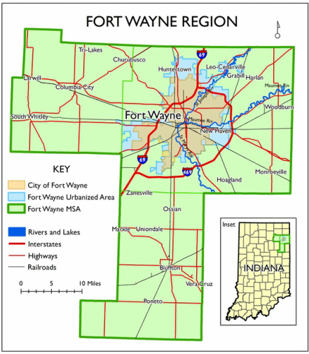
Map Created by Author; Data Source: [38]
|
